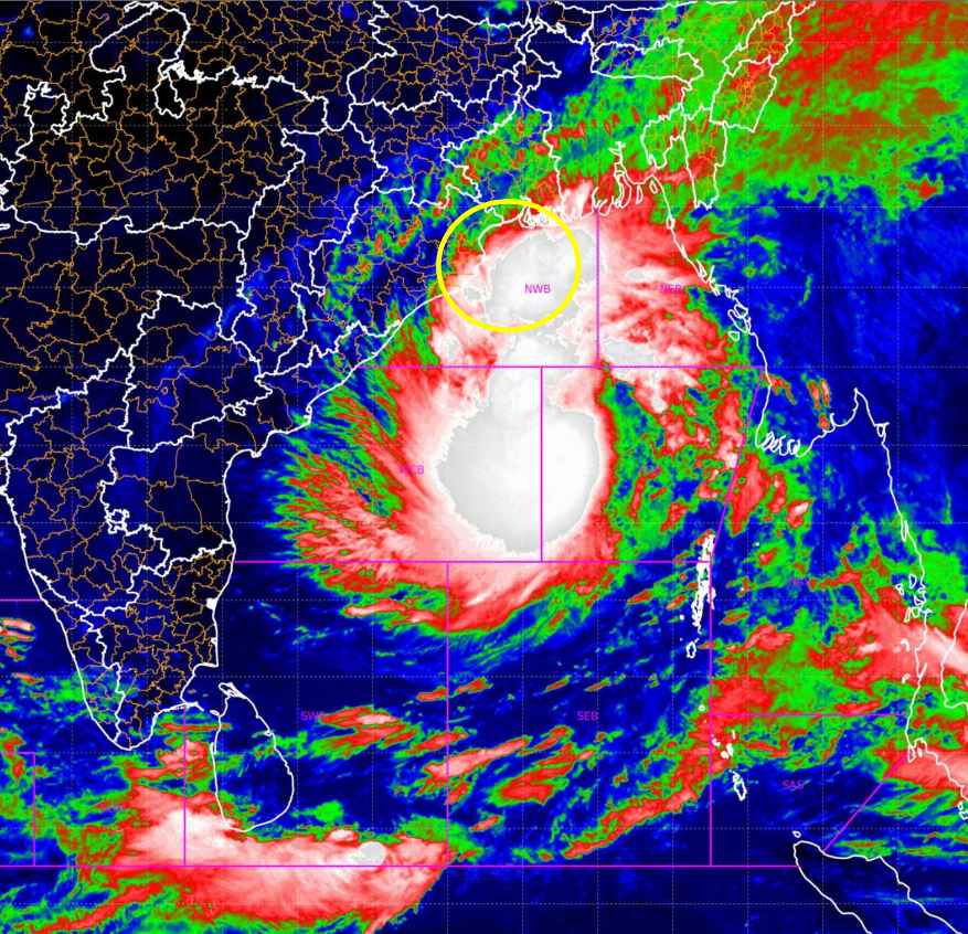
India Meteorological Department (IMD) Update on Cyclone Dana
The India Meteorological Department (IMD) has issued a critical update on the weather situation as the low-pressure area over the Bay of Bengal has developed into a depression. This system is expected to intensify into Cyclone Dana in the next 24 hours, with further strengthening into a severe cyclonic storm by October 24th.
Cyclone Tracker and Landfall Predictions
According to IMD, Cyclone Dana will move in a west-central direction and is projected to make landfall between Puri, Odisha, and Sagar Islands, West Bengal, between the midnight of October 24th and the morning of October 25th. The storm is expected to bring sustained surface winds of 100 to 110 kmph, gusting up to 120 kmph.
| Event | Date | Intensity |
|---|---|---|
| Cyclonic Storm Formation | October 23rd | Cyclonic storm in Bay of Bengal |
| Severe Cyclonic Storm | October 24th | Intensification expected |
| Landfall | Midnight of October 24th to Morning of October 25th | Severe cyclonic storm between Puri and Sagar Islands |
Heavy Rainfall Expected in Odisha, West Bengal, and Jharkhand
Under the influence of Cyclone Dana, heavy to extremely heavy rainfall is forecasted across several regions. The most affected areas include Odisha, Gangetic West Bengal, and Jharkhand, with rainfall amounts exceeding 20 cm.
Rainfall Forecast (October 24-26)
| Region | Rainfall (cm) | Date |
|---|---|---|
| Odisha (North Coastal) | 30-40 cm | October 24th |
| Gangetic West Bengal | 20-30 cm | October 24th |
| Jharkhand | Heavy rainfall | October 24-25 |
| North Coastal Andhra Pradesh | Isolated heavy | October 24-26 |
| South 24 Parganas, West & East Medinipur | More than 20 cm | October 24-25 |
| Mayurbhanj, Balasore, Bhadrak (Odisha) | More than 20 cm | October 24-25 |
Wind Impact and Damage Likely
During the landfall, winds ranging from 100 to 120 kmph are expected, particularly affecting Balasore, Bhadrak, Kendrapara, Jagatsinghpur in Odisha and Jhargram, West & East Medinipur in West Bengal. These strong winds pose a significant threat to infrastructure and may cause:
- Damage to kutcha houses and roads
- Possible harm to pukka houses and roads
- Disruption of communication lines (telephone and mobile towers)
- Damage to electricity supply lines
Train Cancellations and Precautions
Several trains have been cancelled due to Cyclone Dana as a precautionary measure. The IMD advises citizens to avoid unnecessary travel, especially in coastal and cyclone-prone areas.
Fishermen and Offshore Activity Warnings
- Fishermen and seafarers in the North West Bay of Bengal and adjoining central areas are strongly advised to return to the coast by October 22nd.
- Offshore activities and tourism in coastal areas should be suspended until further notice.
FAQs
What is the latest update on Cyclone Dana? Cyclone Dana is currently a depression over the Bay of Bengal and is expected to intensify into a severe cyclonic storm by October 24th, making landfall between Odisha and West Bengal on October 25th.
Which areas will be affected the most? The cyclone will impact Odisha, West Bengal, and Jharkhand, with heavy rainfall and high winds affecting coastal regions.
Are there any travel restrictions? Yes, several train services have been cancelled due to the cyclone, and tourism in coastal areas is discouraged.
What safety measures should be followed? Residents in affected areas should follow IMD guidelines, avoid coastal regions, and secure their homes from potential wind and rain damage.
For live updates, you can follow the Cyclone Dana Tracker and monitor the live weather updates on the IMD website. Stay safe and follow local advisories for precautions against Cyclone Dana.