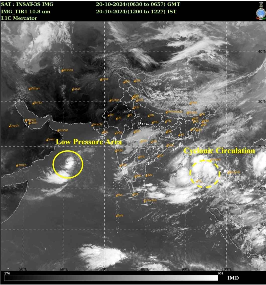
The Regional Specialized Meteorological Centre (RSMC) for Tropical Cyclones in New Delhi has issued a modified tropical weather outlook for the North Indian Ocean, focusing on the Bay of Bengal and the Arabian Sea. A cyclonic circulation has been detected over the Andaman Sea, with forecasts indicating the formation of a low-pressure area, likely to intensify into a cyclonic storm by October 23, 2024.
Formation of Cyclonic Storm in Bay of Bengal
According to the India Meteorological Department (IMD), the cyclonic circulation over the north Andaman Sea is likely to develop into a low-pressure system within the next 24 hours. It is expected to strengthen into a depression by October 22 and further intensify into a cyclonic storm by October 23 over the east-central Bay of Bengal.
The storm is projected to move west-northwestwards and reach the northwest Bay of Bengal near the Odisha-West Bengal coasts by the morning of October 24.
Key Alerts and Warnings
1. Wind Warnings:
Andaman Sea: Squally winds with speeds reaching 35-45 km/h, gusting to 55 km/h, are expected over the Andaman Sea until October 21.
East-central Bay of Bengal: Wind speeds are forecasted to increase to 40-50 km/h, gusting to 60 km/h, on October 21, and further intensify to 70-90 km/h, gusting to 100 km/h, from October 23 evening until October 24 morning.
North Bay of Bengal: Gale winds reaching 100-110 km/h, gusting to 120 km/h, are expected from October 24 evening to October 25 morning, affecting the Odisha-West Bengal coasts.
2. Sea Conditions:
Andaman Sea: The sea is expected to be rough to very rough till October 21.
East-central Bay of Bengal: Rough sea conditions are likely from October 21 morning, worsening from October 22 evening until October 24 morning.
North Bay of Bengal: Sea conditions are anticipated to become very rough from October 23 morning and high between October 24 and October 25.
Odisha-West Bengal coasts: Very rough sea conditions are expected from October 23, with high sea conditions developing from October 24 evening.
Fishermen and Maritime Warnings
The IMD has strongly advised fishermen to avoid venturing into:
- The Andaman Sea until October 21.
- The east-central Bay of Bengal from October 21 to 24.
- The north Bay of Bengal, Odisha, and West Bengal coasts from October 23 to 25.
Fishing operations are recommended to be suspended in the affected areas, and fishermen already out at sea should return to the coast by October 21. Authorities are urged to regulate offshore, port, and maritime activities, particularly in the tourism sector in the Andaman and Nicobar Islands.
Heavy Rainfall Forecast for Coastal Areas
The storm system is likely to bring heavy rainfall to Odisha and West Bengal starting from October 24. Residents in these areas are advised to stay informed and take necessary precautions as the system progresses.
---
Frequently asked Questions
Q: When is the cyclonic storm expected to form? A: The storm is expected to form around October 23, 2024, in the east-central Bay of Bengal.
Q: What areas are likely to be affected? A: The system will likely impact the Bay of Bengal, Andaman Sea, and coastal regions of Odisha and West Bengal from October 23 to 25.
Q: What are the wind speeds predicted for coastal areas? A: Winds could reach speeds of 100-110 km/h, gusting to 120 km/h, from October 24 evening to October 25 morning along the Odisha-West Bengal coasts.
Visit : https://mausam.imd.gov.in/ for more details.